Blog

BRONZE AGE SETTLEMENT IN ORANMORE

20090415-_DSC0068

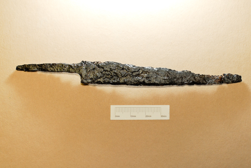
This post is more from a series of posts on the exciting results of excavations carried out by Moore Group at  Pairc and Clochair, Oranmore, County Galway between 2008 and 2010. A number of sites were excavated in advance of construction of a new supermarket and associated access and other services. This time – a Bronze Age Settlement site. this site was excavated by Tamyln O’Driscoll and the following is from her report. In this post we’ll provide a little background and describe the finds. Next time a detailed description of the Bronze Age Structure and then some info on the environmental remains from the site (I know that that’s an Iron knife pictures above but read on – there was also some later material).

Bronze Age settlement sites – a background.

Bronze Age houses in Ireland were generally sub-circular structures or roundhouses with diameters of between 2m and 9m, generally with south-east facing entrances and some examples even had porch entrance features (for details of a bronze age roundhouse excavated by Moore Group in County Clare see here). In some upland areas stone was used for the construction of these houses however the majority were built of wood either post built or foundation trenches, in some circumstances both methods of construction was employed. Excavations of a Late Bronze Age hillfort at Mooghuan South Co. Clare revealed extensive layers of occupation debris which included two small circular house structures. During the excavation of the N8/N73 Mitchelstown relief road the foundations of three Middle Bronze Age houses were discovered. The houses consisted of shallow slot trench foundations, which was roughly sub-circular in shape and a hearth feature was also present, some had a central ring of postholes which would have held posts that were used to support the thatched roof structure. Like many of the other Bronze Age house sites, Feature 1 at Oranmore, the possible house site, also had a hearth feature further supporting a domestic use for the site. At Carrigillihy Co. Cork traces of two phases of house construction were excavated. The house sites were surrounded by an enclosing stone wall which was oval shaped in plan. The two houses overlay one another, the earlier house consisted of the stone foundations of an oval shaped structure that was superimposed by a secondary stone square shaped house. The earlier house dated to the Early Bronze Age to Late Bronze Age transitional period. In the floor of this earlier structure several pits of various sizes and depths were discovered (O’Kelly 1989 219-222). These bear similarities to the large pits discovered below the metalled floor surface of the possible house site at Pairc an Clochar (Feature 1). One of these large pits (Feature 2) which was found below the hearth and associated midden and contained a chert flake within the basal fill of the pit. It is likely from the finds and the comparative material from other excavated house sites that Feature 1 along with its associated hearth, midden and pits were indeed part of a Bronze Age house structure.

However unlike other Bronze Age houses the structure at Pairc an Clochar did not have any structural features in the form of postholes for roof support, gullies or slot trenches foundations nor was there an entrance feature. It is possible from the evidence that the site was located in a natural hollow and may have been a sunken structure, this design would have been necessary in the coastal location of Galway Bay where the weather conditions would have made a standard post built house impractical.

Location

Coastal occupation sites have been favoured from prehistoric times for their proximity to rich food sources and are often represented by habitation sites and middens. Shell middens are the rubbish dumps of the unwanted shells from oysters, limpets, periwinkles. Shellfish meat has been use as food source since earliest times up until the present. Shell middens of various dates are known around much of the Irish coast, two middens of prehistoric date were excavated at Sutton and Dalkey Co. Dublin (Waddell 1998, 19). Rivers were also important areas of activity, serving as route ways, boundaries, defences and ritual sites. The site was located on a gentle gradient sloping down to the seashore; this meant the site was well drained. It was also situated in this position to provide good views in all directions. The location of the site in close proximity to a  Bronze Age ring ditch (which we’ll describe in a later post) also may have influenced the location of the Bronze Age settlement activity. It is likely that the occupants of the settlement site were also those that constructed the ring ditch and may have had ancestral ties to the location.

The Finds

The pottery recovered from Area 3 ranges in date from the Bronze Age (c2500 to c700BC) to the Late Medieval period (1300 to 1500AD) with occasional pieces of pottery also dating to the modern period. The pottery assemblage from the Bronze Age comprises thin wall fragments suggesting that the vessels were small-sized with extant wall thicknesses of 4-9mm. One sherd is from the basal area of a pot that may have had a slight foot. The assemblage is likely to have a domestic use as indicated by soot accretions on the inside of one vessel. One fragment appears to be from a mould fragment and was found in the primary fill of the sub-rectangular house Feature 1. The mould fragment does not have extant metal residues but the curvature is similar to mould fragments from Bronze Age metal-production sites such as Lough Gur, Co. Limerick and Dun Aonghusa, Aran Islands (Cleary 1995). During the Bronze Age clay moulds were used for casting a variety of bronze artefacts such as axes, knives and daggers. The presence of a mould at the site may suggest that smelting technology may have been conducted by the occupants of the site. Clay mould fragments dating to the Late Bronze Age have been discovered during excavations at Rathgall hillfort Co. Wicklow (Kelly 1989, 159). Further metal working activity is possible from the baked clay and slag items found at the site. However the material is not extensive enough to suggest that this activity occurred at the site and may have taken place nearby.

Several unidentified worked bone objects were found during the excavation of Area 3 and were all from the fill of a large pit feature, which also contained other unworked animal bone and the skeletal remains of a dog. Further worked bone objects were found which consisted of a worked pig metacarpal fragment with a circular perforation and a worked metatarsal from a sheep or a goat which may have been intended for use as a bone handle. These bone objects represent a continuity of industry at the site in terms of manufacturing of bone into objects from as early as the Bronze Age to the Late Medieval period.

An iron knife was found during the excavation of a large pit in the basal fill.  This knife consisted of a thin metal blade which was likely to have been used as a domestic knife which would have had a wooden or bone handle attached. At Baronstown Co. Meath excavations revealed a circular ringfort dating to the Early Medieval period, amongst the finds uncovered at the site were several iron knives. At Cabinteely Co. Dublin a large pre-Norman enclosed cemetery was excavated, the sequence of burial took place from the 5th/6th century to the 11th/12th century AD. Amongst the finds discovered directly in association with these burials were a number of iron knives. Excavations at The Old Orchard Inn in Rathfarnham Co. Dublin revealed the site of a possible ecclesiastical site enclosed by a palisade enclosure. This early medieval phase of occupation was followed by the use of the site for burial purposes. The site was subsequently used again for occupation in perhaps the 12th or 13th century AD.

Iron knives were found in the palisade trench as well as a large amount of animal bone, a penannular brooch terminal, and a ‘pig fibula’ pin suggesting occupation of a domestic nature for the earlier phase of occupation. An iron knife, identical to the one found at Pairc an Clochar, was discovered during excavations at an Early Medieval enclosed settlement at Faughart Lower Co. Louth in advance of A1/N1 Newry to Dundalk road. The site consisted of a double ditched enclosure which expanded into an ecclesiastical cashel or stone fort, later the site was used for burial during the 5th to 6th centuries AD.


THE LEGACY OF MEYRICK

1798
The Galway Independent reports this week that the ‘high-profile Meyrick Hotel on Eyre Square has suffered an almost 90pc collapse in value since its €70m peak’ , having been written down to a value of €7.8m in 2011, a remarkable achievement for any Irish property.

The hotel has had a chequered history since its opening in 1852, and has undergone numerous changes in the intervening period. Originally known as the Railway Hotel, it was perhaps best known as the Great Southern Hotel until it was renamed by the new owner in the mid 2000’s to the ‘Meyrick’ (for more on the history of the hotel see our blog post here). The name comes from a General Meyrick, after whom modern day Eyre Square was once named.

Meyrick had a ‘colourful’ life in the British military, beginning his career at St. Kitts, where he served under Admiral Hood against a larger French fleet commanded by the Comte de Grasse. Returning home he suffered from Yellow Fever and subsequently married into a fortune… and unsurprisingly rose in the ranks rather rapidly afterwards.

But it was in Ireland where he had his greatest ‘achievements’.

His obituary describes his Irish service as being ‘unattended with brilliant glory or renown… the enemy being unknown until his appearance’. Nonetheless he served dutifully suppressing the rebellion at Dulleek/Tara where his men bore a ‘great deal of fatigue’ but killed ‘all they met with’, Knightstown, Co. Meath, where ‘many rebels were killed’ and at Wexford, which he ‘relieved and restored to tranquility’.

In 1799, as General of the District (presumably Clare and Galway), he led raids throughout Clare, ‘burning, ravaging and destroying all before (them)’. His actions successfully ended the rebellion in Clare and claimed at least 300 rebel lives.

In March of 1799 he oversaw the trials of the captured Clare rebels. Some were sentenced to death, some to transportation to serve in the Prussian army, others to jail, whipping or transportation elsewhere. ‘All of the seven sentenced to death were brought back to their own towns to be executed’. The executions drew huge crowds, and two of the leaders were left on the gallows for three hours as an “awful warning to the spectators”.

His magistrates’ justice also extended to a county wide curfew – ‘anybody found out of doors between one hour after sunset and sunrise was liable to be handed over as a recruit to the British Navy, as was anyone taking an unlawful oath or found assembled in a public house after 9 at night or before 6 in the morning’.

And as for Galway, of which I’m sure he was very fond, he was called on to oversee the ‘martial court’ in the prosecution of 400 United Irishmen from throughout the county charged with treasonable offences, ‘murder and houghing {severing the Achilles tendon of an animal}’, of whom 30 were sentenced to death by hanging, 50 to transportation and 30 whipped. He later had a wall built around modern day Eyre Square and received the honour of the citizens who named the site after him.

He died peacefully of dyspepsia (indigestion, poor man) at the home of his son in Berkeley Square, London at the ripe old age of 66.

It’s always rankled me a little that the owners of the Great Southern chose the name ‘Meyrick’ as he was associated with those rather unsavoury (to say the least) events during the 1798 rebellion and subsequently – perhaps the owners didn’t really look into his activities and just assumed it would be a nice historical sounding name for a landmark Galway Hotel. And well, perhaps a name like Mellows doesn’t have the same cachet as the aristocratic sounding ‘Meyrick’.

Meyricks Obituary was retrieved here.

His Activity in Clare retrieved here.

Some of his Wexford work from here.

Galway from here.

More in Louth here:

And for info on the Battle of St. Kitts see here:

https://en.wikipedia.org/wiki/Battle_of_Saint_Kitts

GREAT SOUTHERN HOTEL, GALWAY

Copy of scan0029

The ‘Meyrick’ Hotel, perhaps better known locally as the Great Southern, in Eyre Square (for a note on the naming see our next post) made some unfortunate local headlines recently. It’s a landmark hotel in the city centre dominating the western end of Eyre Square and is no stranger to controversy. Moore Group were involved in some restoration/redevelopment works in 2004 and we though it opportune to publish a brief history of this historic and significant local landmark.

The hotels history begins with the construction of the railway in the mid 1840’s. The Midland Great Western Railway of Ireland was incorporated on 21 July 1845, with the authority to construct a railway line from Dublin to Mullingar, Longford, Athlone and Galway. The railway was to follow the route of the Royal Canal, which the Railway had acquired.

It was five years before plans were being finalised for bringing the Railway to Galway.  There was some difficulty in obtaining the necessary funds for the construction of the railway from Mullingar, but the continuing distress of the poor in the West and the possibility of alleviating that distress by providing work on the railway were taken into account and a £500,000 government loan was advanced in 1849.  William Dargan was given the contract for the construction of the entire line and work began late in the same year.

Initially it was the intention to bring the Railway to Renmore, but lobbying by a number of people including ensured that the line crossed Lough Atalia to reach Eyre Square.

On Monday the 21st of July, 1851, the first train arrived in the station at Galway and on the first of August of the same year the line was opened for passenger traffic.

As the hotel was considered an integral part of the Railway, it was decided by the MGWR to divert some of the £500,000 loan they had received to construct the line into building the hotel, a decision not initially favoured by a number of the company’s shareholders, but considered by the company to be beneficial to the railway in the long term by increasing significantly the passenger traffic to Galway.

The size and grandeur of the hotel in Galway suggests a greater plan than simply the construction of the Railway.  From the 1830s it became apparent that it was intended in many quarters that Galway would become a major transatlantic port. The MGWR engineer, George Willoughby Hemans, prepared a report on the feasibility of such an idea and the Railway was closely linked to these plans. An early guide to the Railway thought that it could not be doubted that the Galway Line would “become sooner or later the ordinary route for passengers and merchandise from Great Britain towards the North American Continent”.  The plans were put into practise for a brief period from the late 1850s, when an Atlantic Royal Mail Steam Navigation Company was established.  In early 1859 the company won a twelve-month contract for a regular seven-day run between Galway and St. John’s, Newfoundland, but the route lasted only three years.

The decision to build a hotel as part of the Galway terminus also reflected a serious need for high class accommodation in Galway.  A report in the Tuam Herald in 1850 emphasised the need, stating that there were only two hotels in Galway and that both were so bad that travellers argued over which was the worst.  The two hotels known to have existed at the time were the Clanricarde Arms, later Kilroy’s hotel and then the Imperial Hotel, founded in 1810 and Black’s Hotel, later Mack’s Hotel, founded around the same time.  Both were located at the top of Eyre Square.

The Railway Hotel at Galway was the first of a number of hotels built by the Midland and Great Western Railway in the West, directed towards tourist traffic on the Clifden and Achill lines.   Later in the 19th century hotels were built at Mallaranny (Mulrany), built by 1897 and already extended by 1900 and Recess, built incorporating an older hotel by 1896.

By January 1850 it was still the intention of the Railway Company to build the Terminus at Renmore, with a visit by the company engineers to finalise plans there in January of 1850.  However, the decision to locate at Eyre Square appears to have been made by the end of the same year, when contracts for the construction were being awarded.  In January of 1851 the order was given that construction begin on the Railway Station.   At the end of the same month Mr. Mulvany, the architect, was asked for plans for the Hotel so that the works could commence.  The building of the Hotel was awarded to William Dargan.  The schedule for the construction of the hotel was extremely tight, with a condition attached which demanded completion of the works by the 1st of August 1852, on penalty of no payment.

By the 20th of December 1851, The Builder was able to report that the terminus was almost complete and that the stonework of the hotel was “in a forward state.” When the first train arrived in July of 1851 the terminus was completed with the exception of the roof, which had been destroyed earlier in the month in a severe gale.   In February of 1852 it was clear that the building was behind schedule, but work appears to have increased in pace and the hotel was opened to the public on the 16th of August 1852 at a total cost of £24,960.1s.10d

A correspondent from the Railway Times in September of 1852 found the hotel already full to capacity.

The Architect of the Railway terminus and hotel in Galway was John Skipton Mulvany, with some additional input into the design of the terminus apparently coming from the company engineer George Willoughby Hemans. The hotel at Galway has been described as “unusually bland” for a Mulvany building.   However, the design was appreciated in certain quarters and there was an unsuccessful plan to build a replica of the hotel in California, for which Mulvany prepared plans.


A note on Mulvany.

Mulvany (1813-1870) was a prolific and successful architect, who carried out commissions for many of the Railway companies as well as for a number of private clients, but was, however, all but forgotten during the second half of the nineteenth century.  Some study of his work was carried out in the early 20th century but it was not until recently that a full survey of his career has been carried out.  From the beginning of his time in private practice, Mulvany worked for the first Irish Railway company, the Dublin and Kingstown Railway, for whom he designed a hotel in 1836 and later a station at the same location.  In 1841, Mulvany designed Blackrock station and Kingstown (Dún Laoghaire) station. In  Dún Laoghaire,  Mulvany enjoyed a virtual monopoly on buildings in the harbour, including both main boat clubs and a number of private dwellings.   Kingstown Boat Club incorporated many of the trademarks of Mulvany’s buildings, such as a concealed roof, nautical railings, and a frieze of wreaths carved in relief. On the incorporation of the Midland and Great Western Railway in 1845, Mulvany was appointed the company architect, a position he held until 1850, after which he no longer worked full time but was engaged for a number of buildings by the Railway.The building for which Mulvany is perhaps best known is the 1850 Dublin Terminus for the Western Railway at Broadstone, a “Neo-Egyptian “ building incorporating the booking offices etc. parallel to the line of the railway and the passenger shed and the main block at the end of the line and at right angles to the railway, much the same as the layout at Galway.

100 YEAR OLD BEER?

Billy will be on the Ray D’Arcy tomorrow morning talking about and sampling what he hopes is a 100 year old beer – tune in around 10.30am.

Story: A 19th or early 20th century brown glass bottle was found in Curracloe, Co Wexford a few weeks ago. It was washed up at the Raven’s Point, still corked and containing a ‘foamy’ liquid. Judging from the lip and rim, the cork was wired down, suggesting that it holds a carbonated liquid, most likely beer, although these bottles were frequently re-used, so the liquid could be almost anything. They were usually made in a mold or later by machine and massed produced in Ireland and Britain. The condition of the glass indicates that it has rolled around in sandy or pebbly water for some time which has removed any other tell-tale markings or moldings. It could contain anything really – here’s hoping it’s beer…

If it turns out to be beer, we’ll be sampling and sending it for analysis by a friendly microbiologist…


NATURA 2000 VIEWER

Natura 2000 is an ecological network of protected areas, set up to ensure the survival of Europe’s most valuable species and habitats. Based on the 1979 Birds Directive and the 1992 Habitats Directive, it provides safeguards for numerous ecosystem services and ensures that Europe’s natural system remain healthy and resilient. If you’ve ever wanted to explore the entire of the EU’s Natura 2000 database (ca 265000 sites) there’s a really useful tool which I’ve just come across available here – http://natura2000.eea.europa.eu/#

A map based viewer, sites designated under the Birds directive are displayed in red and in blue for the habitats directive. You can carry out searches by location, site type or particular species. It’s a great resource and should be of particular use for early assessment for developers or planners. It’s nicely intuitive and you can flip between aerial view and map view very quickly, with an opacity button to enhance whatever element you want.

Here’s a screenshot (just click to embiggen):

Natura 2000 Viewer