There we are then – Late adopters of Facebook. You’ll find us here:
https://www.facebook.com/mooregroupgalway
There’ll be the usual updates, stories, news items and links to our blog posts.

There we are then – Late adopters of Facebook. You’ll find us here:
https://www.facebook.com/mooregroupgalway
There’ll be the usual updates, stories, news items and links to our blog posts.
 We’ve been nominated (self nominated to be honest, although maybe someone else suggested us too) in the Galway City and County’s First Ever Online Marketing Awards. There are almost 200 nominees, and we’ve been nominated for the Online Marketing Leadership Award, Best Website, Best Blog and the Peoples Choice Award.Feel free (please) to vote for us in the Peoples Choice Award by clicking here and ticking us….
The Osteoarchaeological report on the remains at Dunmore was completed by Camilla Lofqvist. What follows is an abridged version of the introduction section of her report, the sex of the remains and their age profile. In the next post we’ll look at their stature and general health. References will follow in a later post. The summary of the excavation can be found here.
It is not often the opportunity arises to analyse a substantial human bone material and in this sense the Dunmore bone sample is exceptional. Ideally, all individuals would need to be recovered from a graveyard to enable a greater estimation of the population statistics but the sizeable sample from Dunmore presents a rare chance to examine the general demography of a community (Arcini, 1999:47).
The osteological examination of the bones revealed that the human remains were from 340 individuals comprising 159 adults, 31 juveniles and 150 children. The information retrieved from each burial i.e. age at death, gender, stature, physique, cause of death, quality of diet, any long term illness or condition, manner of lifestyle (e.g. physical work), has helped to build a profile of life and death in Dunmore and has provided us with an interesting, fascinating and rare opportunity to study the everyday life of the population of this north Galway community in the 15th to 18th century.
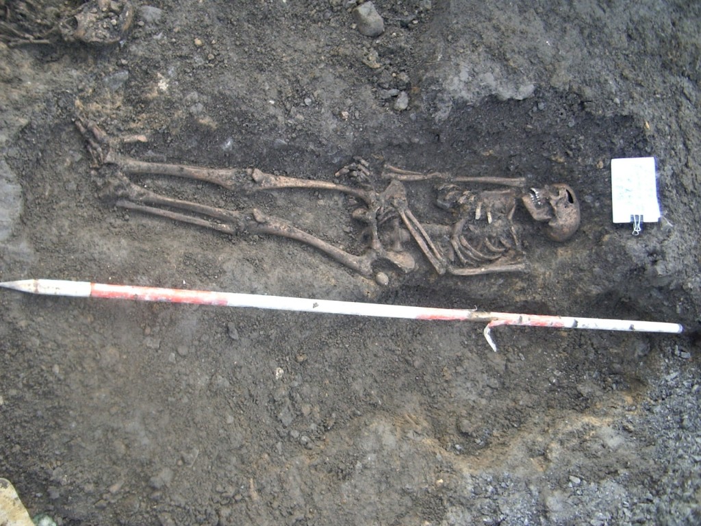
The common medieval graveyards in Europe were often surrounded by walls, hedges or banks and the parish church was often located within their boundaries. However, occasionally the parish graveyard was associated with, for example, centres of education or religious institutions. An expansion of religious orders such as the Franciscans and the Jesuits during the Counter-Reformation resulted in the option of being buried within the monastic graveyards. The location of a burial in the graveyard was considered to be of importance and a burial inside or around the porch of the church was reserved for the most important and most well situated individuals of the society. The less well off were interred outside the church where the preferred location was just to the south of the church wall, although a location to the east and west were accepted. The north of the church was considered the Devil’s side of the church and was mostly avoided. In Dunmore the remains were generally orientated east-west in the Christian tradition (fortuitously running in line with the trench for the surface water sewer). This coincidence in alignment allowed, for the most part, the full recovery of the individual skeletons. In most cases, the remains were uniformly aligned in the extended supine position with the head at the western terminal facing east, the arms and hands were generally crossed over the pelvis/chest or simply extended by the side. The feet were in the majority of cases placed side by side.
In the medieval period it was common to cut through previous burials. The larger skeletal fragments of the disturbed remains were stacked in one corner of the new grave or, if the fragments were small, were just left in the soil used to backfill the gravecut. It was also common to place disturbed human remains in a communal ossuary. This tradition tends to live on in Ireland and England up to present day (Mytum, 2004:160). The numerous stray human bones and the high degree of intercutting of the burials at Dunmore suggests there was a high demand on space in the graveyard. It is possible the pressure to inter the inhabitants within its grounds, resulting in frequent intercutting, could have been due to the lack of space but it could also be that certain areas in the graveyard were favoured, such as a location close to the church. Many of the burials did respect previous ones indicating that there may have been external markers on the surface demarcating individual plots. In a number of cases there was evidence of burials interred in very close proximity suggesting the possibility of family plots that were re-used over generations. The location of the burials in Dunmore suggests these individuals were not from the highest stratum of the society. It is likely the graves of the more well off in Dunmore were located within or just outside the church.
The most common method of interment during this period was a simple earth grave, often with a rectangular shape. At times the gravecuts in Dunmore were clearly visible but often the shape of the cut was unclear due to intercutting or other factors. However, the shape of the cuts seemed to vary, occasionally the cut was so narrow that the skeleton seemed to have been squeezed into it resulting in a raising of the shoulders. The depths of the burials also varied. It was notable that the earlier, deeper inhumations appeared to have had wider cuts and the remains were less constricted. Later burials were interred in narrower cuts and the limbs seemed more confined. This lack of available plot space may indicate a degree of congestion within the graveyard in the late seventeenth to early eighteenth century.
The lack of any associated coffins suggests that the inhumations in Dunmore were interred in simple grave cuts, probably wrapped in a shroud fixed with a pin or nail. In England regulations were brought in between 1660 – 1678 stating that these shrouds had to be of wool. This was done to increase and support the English wool industry. Any headstones that may have originally been erected were likely removed off site in the mid eighteenth century under the direction of Lord Ross to clear a path for the avenue leading to his demesne. Amongst the corpus of skeletons there was no obvious distinction between gender or age. Males and females were found buried alongside infant, juvenile and adult remains confirming the community nature of the graveyard as distinct from a burial ground solely servicing a monastic order.
The Dunmore sample suggests that a slightly higher degree of males (46.5%) were present in the skeletal assemblage compared to females (41.5%). However, it should be remembered that c. 12% of the individuals in Dunmore could not be ascribed to either sex due to the deteriorated and fragmented state of the bone.
The 340 individuals recovered in Dunmore, of varying ages and conditions of preservation, represented the remains of 150 children (age-at-death ≤ 12 years), 31 juveniles (age-at-death between c. 12-20 years) and 159 adult individuals (age-at-death >20 years). In general, children tend to be most frequently represented in the archaeological record, followed by young adults and a more limited number of older adult individuals.
The high frequency of children and young adults in the Dunmore material and the less frequent retrieval of older adults conforms to the common findings of other graveyard material. However, the possibility of older individuals being buried in a different location in the graveyard and therefore not recovered must be considered.
Next time – the stature and general health of the Dunmore remains.
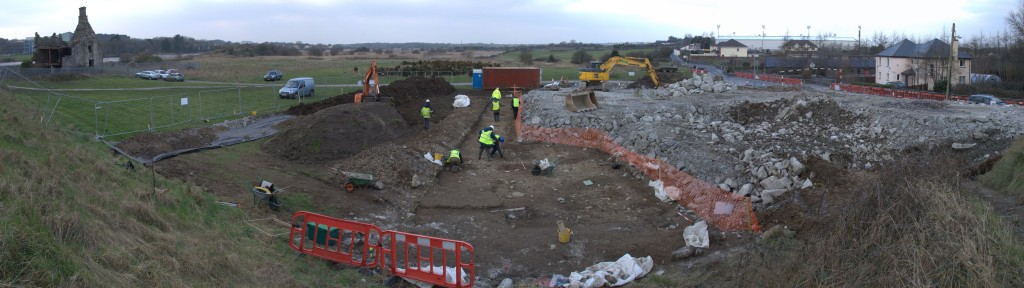
Back in our pre-blog days in 2006 and into the beginning of 2007 (perhaps the boomiest of the boom years), we completed our biggest excavation to date at Dunmore, Co. Galway. We haven’t blogged the results until now and we’ll be posting the results over the coming days. First off – an introduction.
The excavation was carried out in the townland of Abbeyland South, Dunmore, Co. Galway between June and October of 2006 and January 2007 on behalf of H.G.L. O’Connor and Co., Consulting Engineers, acting for Galway County Council. The proposed construction works involved the excavation of a linear trench running E/W along the northern carriageway of Barrack Street to accommodate the installation of a surface water sewer. Archaeological monitoring of groundworks in May 2006 identified the remains of two articulated skeletons confirming the anecdotal reports of the possibility of a graveyard in the area of Barrack Street (according to local sources groundworks for a water service carried out by the council in the late 1980’s had disturbed human remains; reports at the time suggested that workmen reburied the exposed bone with the backfill). Following this discovery the remains were covered with terram and all works in the immediate area were suspended. As it was not possible to re-route the proposed surface water sewer on Barrack Street, it was decided following consultations with the relevant stakeholders to excavate the human remains in the vicinity of the Friary. The nearby Augustinian friary in Abbeyland South is part of the historic town (GA017-002) of Dunmore, County Galway and is a national monument in state ownership.
Excavation was carried out along the length of the road working generally from west to east and directed by Billy Quinn. In total 288 individual remains were recovered. These remains represent a community graveyard located to the south of the Augustinian friary that runs the length of extant church and continues under the road comprising an area at least 53m E-W by 17m N-S incorporating an 884 sq. m. In terms of external monuments there was no evidence for marker stones or grave slabs associated with any of the burials. Presumably any headstones that may have originally been erected were completely removed off site in the mid eighteenth century under the direction of Lord Ross to clear a path for the avenue leading to his demesne.
It would also appear from the lack of any associated coffins that the inhumations were interred in simple grave cuts, probably wrapped in a shroud affixed with a pin or nail. The only other burial elements of particular note were two instances where ear-muff stones were placed to protect the head.
The phasing of the burials was quite difficult to determine due to the narrow strip excavated but it would seem that the older burials were interred at a greater depth and that later grave-cuts routinely impacted on earlier remains. Notwithstanding this most burials did respect previous ones indicating that there may have been external markers on the surface demarcating individual plots. In a number of cases there was evidence of burials interred in very close proximity suggesting the possibility of family plots that were re-used over generations.
Amongst the corpus of skeletons there was no obvious distinction between gender or age. Males and females were found buried alongside infant, juvenile and adult remains confirming the community nature of the graveyard as distinct from a burial ground solely servicing a monastic order.
In most cases, the remains were uniformly aligned in the extended supine position with the head at the western terminal facing east, the arms and hands were generally crossed over the pelvis/chest or simply extended by the side. The feet were in the majority of cases placed side by side. It was notable that the earlier, deeper inhumations appeared to have had wider cuts and the remains were less constricted. Later burials were interred in narrower cuts and the limbs seemed more confined. This lack of available plot space may indicate a degree of congestion within the graveyard in the late seventeenth to early eighteenth century.
A number of exceptional remains not conforming to the standard burial rite are worth commenting on. These involve crouched burials, burials placed on their side and in two cases burials interred front down or in the prone position.
Of the 5 crouched burials excavated, 4 look to have been deliberately placed in this position legs drawn upwards, head to the side and arms bent at the elbow. One burial appears more haphazard, its position suggesting a lack of formality or hastiness in its interment.
Five burials were positioned on their sides. These may have been deliberately placed so or may have simply slumped to the side of a narrow cut. Two burials were buried front down.
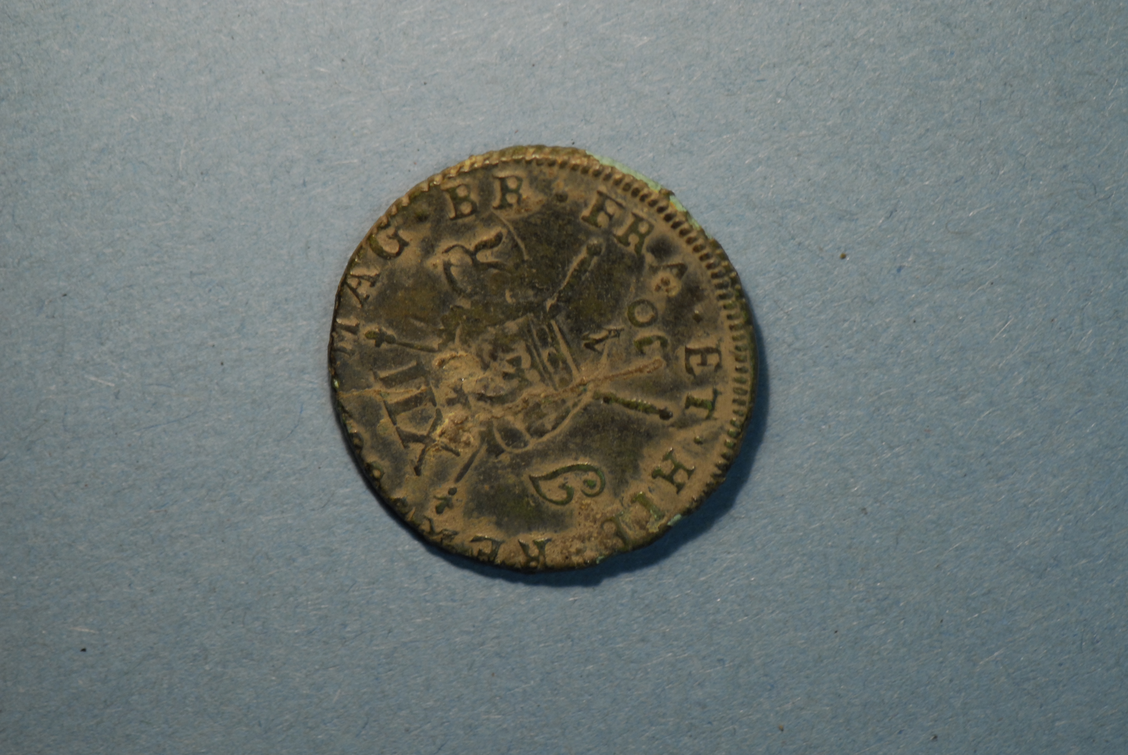
Fifty one artefacts were recovered, including corroded nails, a number of pins, assorted sherds of pottery and some tile fragments. The best evidence for dating came from 2 coins. One coin is a James II gunmoney small shilling dated to 1690. The ’gunmoney’ coinage was struck from brass obtained from old cannon, bells and other sources of scrap metal. It was issued by James II as an emergency token currency, which would be exchanged for good silver once he had won the war against his Protestant foe, William III. In the event, James was defeated and after circulating briefly at their intrinsic value, the coins were demonetized in 1691.
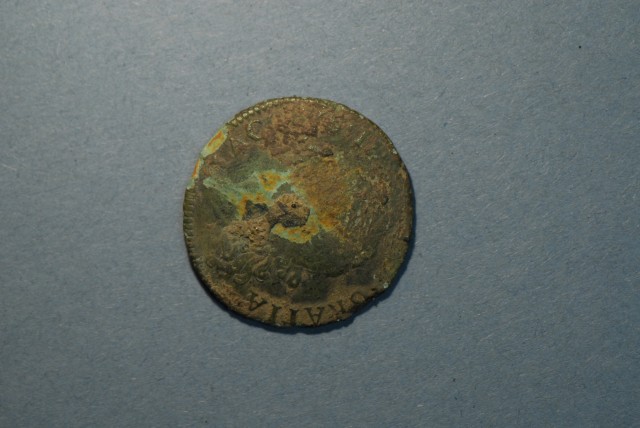
Obverse showing profile of James II with legend ‘Jacobus II Gratia’.
 ‘MAG BR FR ET HIBERNIA’ – image of crown and sceptres flanked by letters J and R and numeral XII.
The second coin is an example of an Irish Halfpenny of Charles II struck in 1681. The legends on both sides are unclear however it is possible to discern (reverse) MAG BR FRA ET HIB REX which translates as Majesty of the Britons, King of France and Ireland. The fact that both coins come from a period within a ten year range of each other broadly dates the skeletons at this remove from the Friary building to the second half of the seventeenth century. The logic of this interpretation is based on the assumption that the earliest burials were interred nearest the church and that over time the burials radiated outwards.
Next: More detail on the osteology from Camilla Lofqvist’s report.
 Archaeological investigations were carried out by Moore Archaeological and Environmental Services Ltd. at Terryland, near the Dyke Road, Galway in early 2013. The archaeological team led by Billy Quinn excavated 10 individuals buried just below the existing surface. The human remains were discovered following archaeological testing of the site during the construction of a proposed multi modal access ramp connecting the Dyke Road with N6/ Bóthar na dTreabh. The work was carried out on behalf of Galway City Council and the National Roads Authority with the advice and assistance of Mr. Jim Higgins, Galway City Heritage Officer. The remains were analysed by Linda Lynch, Osteoarchaeologist. The excavations were carried out under licence to the Department of Arts, Heritage and the Gaeltacht.
The skeletons were all in a poor state of preservation and some had been previously truncated by earlier groundworks in the area. The remains consist of seven adults and three juveniles. Of the seven adults four were males and three females. All the burials were orientated east west – however three of the individuals, contrary to traditional practice, were interred with their heads to the east. Also of note were the varying positions of the arms and legs – usually in graves from this period the arms lay alongside the body and the legs were extended. In the Terryland cemetery the remains were buried less formally with the arms bent at the elbow or with the legs flexed. All the burials were interred without coffins – however a number of nails were found within the grave cuts. These may have been used to fasten a shroud or a winding sheet. It would appear, based on the level of the graves, their general arrangement and the lack of phasing, that the remains were buried broadly contemporaneously.
A number of samples were selected for radiocarbon dating, and were given a broad date range with a likely convergence in the 17th century. This general date was corroborated by a number of pottery sherds found in association with the grave cuts.
The remains were discovered to the immediate east of Terryland Castle. From both historical and cartographic records it is known that this area was close to a fording point to the south of present day Jordans Island and that there was a castle here in 1574 (O’Flanagan 1927a, Vol. 1, 166-7). From the available sources it would appear that this building was replaced by a gabled house built by the fourth Earl of Clanricard, Richard Burke. The castle was the scene of a number of military engagements throughout the 17th century. During the Confederate wars (1641-1653), when the inhabitants of the town were in dispute with a garrison at Forthill, the fifth Earl, Ulick, dispatched his Lieutenant, Dermott O’Daly, along with three companies and thirty musketeers to take charge of his castle at Tirellan. The castle was described as being situated on a neck of land commanding the river Corrib (Hardiman 1820, 112). From this position O’Daly was able to assist the townspeople in preventing supplies being delivered to relieve the Forthill garrison.
Later, in advance of the Cromwellian siege of 1652, the Earl is recorded as ‘repairing to Tirellan’ in order to establish a committee to beseech the Duke of Lorraine for assistance from the advancing English. These negotiations failed and in August of 1651 Sir Charles Coote blockaded the town by taking the castles at Tirellan, Oranmore and Claregalway. The siege was to last for nine months before the Governor of the town finally surrendered. It is notable that the treaty of capitulation signed on the 5th of April 1652 included the following ‘Sir Valentine Blake, Sir Oliver Ffrench, John Blake esquire and Dominick Blake, were to be delivered as hostages to Coote and finally ‘the new castle at Tirellan and the fort of Mutton island were to be surrendered.’ (Hardiman 1820, 132).
The next known violent chapter in the history of the castle took place during the Wars of the Two Kings (1689-1691). Following the defeat of the Jacobite army at Aughrim only Galway and Limerick stood in the way of a complete victory for the Williamite forces; Colonel Lutterel commander of the English approached Galway from the west intent on besieging the town. The advancing cavalry were met with opposition from both French and Irish troops manning advanced posts. In one particular skirmish the castle of Tirellan (Terryland Castle) was burnt to prevent the enemy making any use of it against the town. The outworks of the castle were held by the Jacobites, until after a number of sorties resulting in the deaths of several English, the defenders were forced to abandon their positions. Given a free hand the English proceeded to burn all the suburbs beyond the north-west gate (Hardiman 1820, 159).
Mindful of these conflicts, and in the absence of any recorded church sites and graveyards in the immediate vicinity, it was initially speculated that the remains exposed at Terryland may have been associated with the aforementioned historical events. This hypothesis was based on the type of pottery sherds and the presence of a clay pipe stem fragment found in association with the human remains; all of which indicated a late 17th-century date (tinglazed ware found in C.6, the grave fill of Skeleton No. 6).
Adding weight to this speculation was the irregular nature of the burials. Certainty the graves were unusual given the conventions of the time. According to Christian tradition burials of this period, as now, were laid to rest orientated in an extended, supine position with the head to the west and the arms along the sides. At Terryland, although the grave cuts were found at relatively the same level and dug in respect of each other, the individuals appear to have been buried without coffins and the positioning of the remains was haphazard. These aberrations included two individuals (Skeleton 5 and 10) buried together in the same grave but in opposing directions, and two other burials (Skeleton 1 and Skeleton 8) buried with their heads to the east, contrary to the norm. Furthermore, in the instance of Skeletons 4, 5, 8 and 9 the lower legs were flexed at the knee, and the arms, where present, were variously bent at the elbow, lying on the sacrum, resting on the pelvis or lying alongside the torso. The randomness of these skeletal attitudes suggests that the individuals were interred in shrouds or winding sheets, possibly using nails as pins, and that the burials were carried out lacking the usual degree of ceremony or respect.
So were these individuals the casualties of war? Analysis of the remains determined that the ten individuals comprised seven adults, four of whom were female and three juveniles. Moreover the majority of the adults were less than 30 years of age. These profiles do not fit with combatants dying in a military action. Furthermore there is no evidence from the skeletal remains of fatal direct impact trauma. What the bones do tell us is a general tale of hardship. The 10 individuals were all under 30 years, a profile that would traditionally be considered the least vulnerable in a population group. Given the high rates of infant mortality it is worth noting the lack of infants. The remains present evidence of physiological stresses, lesions and Schmorl’s nodes all evidence of hard labour throughout their relatively short lives.
Ireland in the 17th century was a dangerous place. From the Confederate Wars (1641-49), through the Cromwellian conquest (1649-53) and the Wars of the Two Kings (1689-1691), the civilian population endured a lasting tumult that decimated the population. Indeed between the two years of 1650 and 1652 it is estimated that a quarter of the country’s population died as a result of a man made famine and its attendant diseases, including typhus and dysentery. In Connaught these privations were compounded by an influx of displaced people, the result of a deliberate programme of land confiscation and transplantation. Given the scale of the calamities endured by the population it is reasonable to conclude that many individuals deprived of their homes, ravaged by war, disease and hunger died prematurely, were buried often in haste, in unconsecrated ground and with little rite or ritual. The unusual burial positions and the lack of coffins suggests that the burials in Terryland do not represent a traditional cemetery for the community, but rather served a more immediate function for the disposal of the dead in a period of stress that disrupted the normal functions of society.
Rather than attempting to tie the demise of these individuals into a known historical event e.g. the 1691 skirmish at the nearby castle, it is more likely that their premature deaths were caused not by the swift violence of war but by the equally brutalising and fatal consequences of it.
 |