Blog

Eyre Square Excavations Part I

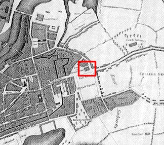
Moore Group was engaged by Galway City Council as the consulting archaeologists for the Eyre Square Re-enhancement Project and from the outset in February 2004 carried out archaeological testing and monitoring of groundworks. A number of excavations were carried out during the scheme. Some post-excavation is ongoing and a final report will be prepared soon. Over the coming months we’ll post some snippets from the excavations here. We’ll start at the top (north end) of the Square and the discovery of an 18th century building.

18th Century building (market house) at north end of Eyre Square

An excavation, directed by Billy Quinn, was carried out to the north of Eyre Square in an area previously utilised as a taxi rank and carriageway (for those of you familiar with the city – that’s in front of the Bank of Ireland). Previous archaeological testing within this area had exposed structural remains indicating the presence of an 18th Century building. Although it was feasible to preserve the building in situ, with the agreement of the DEHLG and the support of Galway City Council, a small part of the area was excavated -the excavation incorporated areas both inside and outside the wall footings to provide meaningful data. Despite the fact that the building could have been left untouched, the City Council agreed that this was a great opportunity to investigate a previously unknown feature prior to sealing it up in perpetuity.

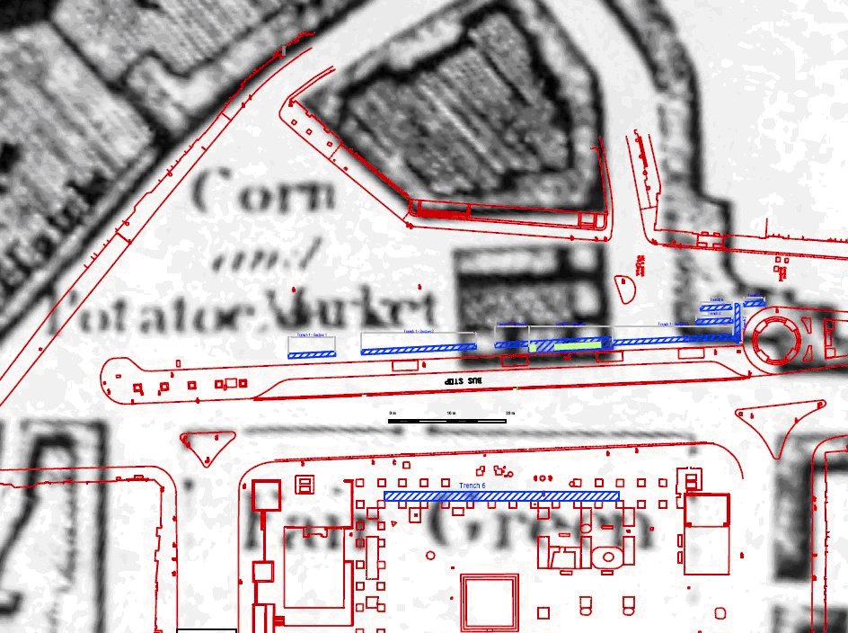
Logan’s map reproduced above depicts the square as a park area indicated both as the ‘Fair Green’ and ‘Mayrick’s Square’. To the north east of the square is an open space known as the potato and corn market. West of this is a square development block with approximately six structures enclosing a yard that corresponds with the square block on the Erasmus Smith 1785 map. This block is located in the area of the present day taxi rank and bus terminal and is most likely related to the wall foundations exposed during the excavation. On the later 1839, 1st Edition OS sheet this block does not appear, presumably having been demolished to enlarge the market space. We’ve reproduced below an extract from Logans map overlaid with the present day site plan showing the structural foundations exposed during excavation in relation to the block described above. The foundations we excavated generally correspond to this long since demolished building.

Prior to the manual excavation a large area to the north of the present day bus rank was machine excavated to an average depth of 0.4m, removing the tarmac, hardcore and underlying mixed gravel layers. This bulk reduction work was essentially carried out to determine the extent of the structural remains previously recorded in the testing phase and to define the limit of excavation. On completion of the stripping operation the exposed open area was roughly ‘L’ shaped in plan with the longer axis orientated NE/SW measuring 21m by 6m and the shorter axis orientated NNW/SSE measuring 10m in width by 10.5m in length. This area was enlarged at a later date to the south, west and northwest. The southern extension was opened to re-expose the south wall; the west and north west extension’s were designed to investigate a possible return on the west wall and to examine a stone lined pit that later transpired to be a latrine with associated drain.

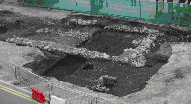
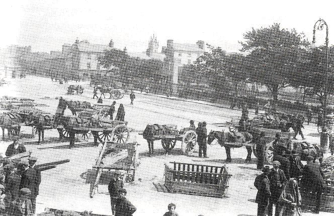
The plate reproduced below, taken from the roof of the nearby Bank of Ireland (who kindly allowed us access), is an aerial view looking south to the site. The plate shows very generally the main archaeological features comprising the foundations of a rectangular building, a circular ash Pit and the stone lined latrine. The slot trench located in order to investigate the stratigraphy inside and outside the wall is evident on either side of the ranging rod.

The earliest deposit exposed during the course of the excavation was the first of three metalled surfaces found within one of several investigative slot trenches. This was a roughly laid metalled surface of sub-rounded, poorly sorted, cobble sized, limestone within a silty peat matrix and measured approximately 0.75m N/S by 1m E/W. Sealing this surface was a softly compact, mid brown, sandy silt, organic layer with inclusions of burnt and un-burnt animal bone, oyster, periwinkle and mussel shell, brushwood and a single gold plated copper pin. Overlying that was a midden-like deposit, varying in thickness from 4cm to 11cm. The only significant find recovered from this layer was a gold plated round headed pin similar to the example found in the deeper layer described above.

Above all that there was another rough cobble layer. From the cartographic record there is evidence for a roadway in the vicinity of the site from the mid 17th Century. This cobbled surface probably represents the final phase of roadway activity prior to the site being re-used, initially as an open market, evidenced by the accumulation of organic refuse (described below), and later for the site of the Market house.

A composite layer consisting of moderately compact, brown clay with frequent inclusions of stone, animal bone and oyster shell was above the 17th century roadway. This layer measured on average 0.2m in depth and contained an assortment of post-medieval finds including pottery, glass, clay pipe, tile sherds, worked shoe leather and two gold plated pins.

The structural remains exposed during the testing phase and the initial mechanical excavation work uncovered a roughly rectangular structure measuring approximately 12m E/W by 6.35m N/S. This rectangular block was open ended to the east with no evidence for a return and was later truncated by a modern service trench orientated NNE/SSW. It was apparent that the building was constructed in two phases, built, partially demolished leaving the southern and western walls intact and rebuilt and enlarged at a later stage. The masonry was bonded with a mid to dark brown coarse sand lime mortar.

Among the other features exposed during the course of the excavation in Areas B and C to the north of the rectangular structure were a circular ash pit, a latrine, and associated drain.
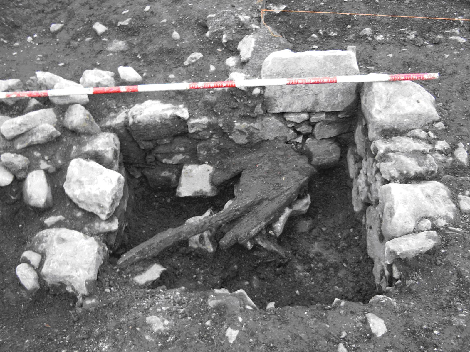
The Latrine

The Latrine, found to the north of the north east corner of the rectangular structure in Area D was initially exposed as a ‘U’ shaped arrangement of stone with an associated drain in the form of a linear stone alignment. Subsequent excavation of the feature revealed a stone lined, rectangular pit with a backfilled drain running to the north. The internal pit dimensions measured 1.03m N/S by 0.5m E/W and had a maximum depth of 0.51m. The stone revetment was constructed of randomly coursed, roughly hewn limestone with smaller spall stones. There was no evidence of any bonding agent. The pit, as is obvious from the photograph, is open to the east – whether this was deliberate or the result of later demolition is unclear. An investigation around the feature to determine the original cut-line exposed a sub-circular fill extending to the west beyond the limits of the extant revetment; this would seem to indicate that the pit was originally enclosed. The fill within the pit was a friable, dark brown silty sand with frequent inclusions of pottery, bone, wood and stones. A worked piece of timber retrieved from the pit had a deliberate hole cut in its mid section and probably functioned as the toilet seat. The entire timber was retrieved and has been conserved.

To the NE of the latrine and running N to the edge of excavation was a drain feature that measured 0.95m in length by 0.5m in width.

We concluded that the remains of the eighteenth century rectangular building were possibly related to the block of buildings marked on Logan’s 1818 map to the east of the old Corn and Potato market. The building probably functioned as the original market house which was subsequently moved to the present day site of the Bank of Ireland. Two distinct building phases were evident suggesting that the original building was partially demolished and enlarged – possibly in the early nineteenth century. By the time of the 1st Edition OS map in 1839 this building had been totally demolished allowing for an extension of the open-air market to the east.

Contemporaneous with this general phase was a latrine and ash pit. Neither of these features appeared to have associated enclosing elements. However it is very unlikely that they were exposed to the elements and were probably sheltered by a timber structure.

Underlying the market house were a series of archaeologically significant organic deposits containing a wide variety of finds including medieval to post medieval pottery and tile, worked leather shoes and offcuts, three gold plated pins, fragments of early clay pipes, an amber bead and a pre-historic flint. Three successive metalled surfaces were also exposed consisting of compacted cobbled sized sub angular stone. These surfaces mark the original roadway as featured on Bellin’s 1786 map leading eastward from the walled town towards Prospect Hill.

Unfortunately due to time constraints brought about by adverse weather the site was not bottomed out to natural levels, however excavation did expose extant archaeological levels at a depth of 1.7m below the existing road level. The preservation in situ of these deposits was made possible by the cooperation of the landscape architects and contractors in raising their finished structural levels to avoid any direct impacts. On the completion of the excavation the entire site was covered with geo-fabric and backfilled with gravel.

Harris online

Edward Harris’ Principles of Archaeological Stratigraphy is available for download online here. The Harris Matrix is now widely used worldwide. The book was first published in 1979 and is the seminal work on stratigraphical theory.

Great Beer Experiment video

Regular readers will have noticed that we’ve posted the video of last years Great Beer Experiment using VodPod on the right…

Produced by BigYes, it documents the process and the events last August – please bear in mind when viewing that we had consumed quite a bit of our beer by the end of the day!

{addendum} …..and Moore Marine’s underwater footage of a Stingray which Eoghan filmed while diving on the Great Barrier Reef near Townsville in Queensland, Australia last year.

Four Stone Hearth #39

Hominin Dental Anthropology is the host of the most recent Four Stone Hearth (39) Blog Carnival. Great blog (seriously, I love that there’s a well-written blog which specializes in ancient teeth)- go visit.

I want to tear down the walls, that hold me inside

U2, The Clarence Hotel, and Protected Structures

I want to run
I want to hide
I want to tear down the walls
That hold me inside
I want to reach out
And touch the flame
Where the streets have no name

Now, this is not a political blog, and we don’t like to embroil ourselves in planning debates either (we like to remain impartial), but our interest was piqued in the proposed U2 led development of the Clarence Hotel by a debate on RTE’s Questions and Answers last night, and the clear and willful ignorance of our politicians on the issue of historic building conservation. In this case two politicians (and we feel fully justified in our criticism as they are from opposite sides of the political fence and yet demonstrate equally ill-informed opinions), Martin Cullen (FF) and Joan Bruton (Deputy Leader of the Labour Party) argued that the proposed façade retention/demolition of protected structures to facilitate the construction of a Norman Foster designed structure to increase the amount of rooms in Bono, the Edge and others’ small hotel in Dublin from 49 to 141-bedrooms (creating a five-star hotel and spa) was an ‘exceptional circumstance’ and justified the removal of the existing buildings. Cullen said he wanted to be consistent in regards to our heritage, whatever that means….. (then again, see this…. and this and this )

The reason for the brief debate on Q & A: the development is currently the subject of an oral hearing with an Bord Pleanala (ABP). On foot of the original planning application the council’s own conservation architect, Clare Hogan, had advised a refusal in her report – stating that the planned development did not meet legal requirements. She expressed concern that the band [and their business partners] was unable to provide “exceptional circumstances” to demolish four neighbouring listed buildings — as required under the Planning and Development Act 2000 (exceptional circumstances required, that is, not demolition).

As of today, the oral hearing into the proposal is ongoing. The DEHLG have also objected… Their objection, which also criticizes Dublin City Council for its interpretation of heritage preservation guidance, was lodged last Friday and follows a request from ABP for its views.

According to the Irish Times on Thursday last this also follows criticism of the hotel plan from Fáilte Ireland which last month told the planning appeals board that it was important the city’s “historic fabric be protected” and that the development “may set an unwelcome precedent for development in the Georgian heart of the city”.

The department’s submission expresses criticism of the council’s senior planner whom it said reported in January that architectural heritage protection guidelines are “negative about, but open to, façade retention”. The department concluded that the “exceptional circumstances that might warrant the grant of planning permission for the substantive demolition of protected structures have not been demonstrated in this application”.

As Tim O’Brien points out in the IT it is likely, given the structures are listed and in an ACA (Architectural Conservation Area) that the Planning and Development Act 2000, which emphasises the retention of whole buildings as opposed to their façades, may, in this case, have given the DEHLG extra teeth.

(According to Chapter 2 of Part IV of the Planning and Development Act 2000 an architectural conservation area is ‘a place, area, group of structures or townscape, taking account of building lines and heights, that is of special architectural, historical, archaeological, artistic, cultural, scientific, social or technical interest or that contributes to the appreciation of a protected structure, and whose character it is an objective of a development plan to preserve’.)

The department said it believed “negative” did not reflect the entirety of its opposition to façade retention in the light of the 1999 and 2000 Planning and Development Acts.

According to a recent Irish Independent report, the council’s conservation architect stated that the Clarence Groups inability to follow procedure meant that the decision was “reminiscent of the climate of 1960’s speculative development”. The proposal is clearly in breach of national legislation and the city council’s own development plans.

Foster & Partners has said that, in order to turn the hotel into a rival of the greatest luxury hotels in the world, the plans have to be drastic. “If we were to keep the building as it is, we would have no scope to create the grandeur and interest that would be demanded for one that aspires to be the worlds best,” the spokesman added.

The proposed development entails the addition to the existing Clarence building of a “skycatcher” atrium topped by a glazed “skyroom” bar with a 360-degree panorama of Dublin. An elliptical canopy with a reflective surface – a “white hovering halo”, as senior partner Andy Bow described it – would oversail it (Irish Independent). The adjoining four-storey buildings, which date from the later period of the Wide Streets Commissioners, would have three-storey glazed extensions added on top, set back somewhat from their façades.

Here’s more from a Frank MacDonald article in the IT last year

Kenneth Browne, who edited the extensive, illustrated supplement, A Future for Dublin, published in 1974, was particularly eloquent about the Liffey Quays. “Without question,” he wrote, “it is the quays which give topographical coherence to Dublin. They are the frontispiece to the city and the nation.

“These riverside buildings are the essential Dublin . . . grand, yet human in scale, varied yet orderly, they present a picture of a satisfactory city community; it is as though two ranks of people were lined up, mildly varying in their gifts, appearance and fortune, but happily agreed on basic values.

“Individually unremarkable as works of architecture, collectively they are superb, and form a perfect foil to the special buildings such as the Four Courts and the Custom House.

“If they are allowed to disintegrate, to be replaced by unsympathetic new buildings, the most memorable aspect of the city will be lost.”

That’s why the Dublin City Development Plan designates the quays as a conservation area and says it’s the city council’s policy to “protect and reinforce [their] important civic design character” and ensure that infill development will “complement the character of the quays in terms of context, scale and design”.

An Taisce’s one-time chairman Michael Smith, who owns a house on Ormond Quay, has condemned the proposal as “execrable” and said “first-rate historic environments” such as Wellington Quay was “not Cape Canaveral [ and] should not be subsumed into one spaceship”.

It’s somewhat surprising, with ex-Minister of the Environment Martin Cullen in particular, that two prominent politicians should heartily disregard the raft of EU and Irish legislation put in place to protect our architectural heritage. From The Athens Conference of 1931 (which established basic principles for an international code of practice for conservation), The Venice Charter, which superseded it, the 1975 Declaration of Amsterdam (The importance of integrating conservation of the architectural heritage into the urban and regional planning process is identified as one of the most important factors) and the Granada Convention which lays down European standards for the protection of the architectural heritage and sets out a range of obligations which states parties undertake, as well as our own legislation, there is a plethora of regulations which need to be accounted for in consideration of a protected structure.

The Council of Europe Convention for the Protection of the Architectural Heritage of Europe states that for the purpose of precise identification of monuments, groups of structures and sites to be protected, each member state will undertake to maintain inventories of that architectural heritage. Ireland’s undertaking under Article 2 of the Granada Convention is now enshrined in the Architectural Heritage (National Inventory) and Historic Monuments (Miscellaneous Provisions) Act 1999. Staff in the (Martin Cullen’s earlier Dept.) DEHLG and expert consultants compile these lists.

More on the debate at

http://www.bdonline.co.uk/story.asp?storycode=3097941&origin=BDweekly

and at Archiseek there’s a lively thread on the issue as well as a poll

http://www.archiseek.com/content/showthread.php?t=6427