PEARSE STREET ATHLONE MONITORING
Pearse Street, Athlone, Co. Westmeath
Archaeological Monitoring
20365 24120
NA
10E430
A programme of archaeological monitoring was carried out in the vicinity of the Revenue Commissioners Building off Pearse Street, Athlone, Co. Westmeath and along Pearse Street.
The works involved the installation of a proposed gas main extension along Pearse Street (approx. 77m of 125mm diameter pipe) and a site main/service pipe on the revenue commissioners’ property (approx 200m of 90mm diameter pipe). The pipe was laid by open cut trenching with maximum trench depth of 1m.
The groundworks took place along Pearse Street on the western bank of the Shannon. From historical records we know that development on this side of the river dates from before 1200. There is a tradition that the priory of saints Peter and Paul was founded by Toirrdelbach Ua Conchobair in or about 1150, as part of a 12th century ecclesiastical reform movement. This foundation, based as it was near a fording point, had obvious strategic importance that was subsequently recognized by the Anglo-Normans. bishop John De Gray of Norwich built the first castle for king John of England in 1210 and the existing building still incorporates elements of this original design. The castle was built to protect a bridge leading to the East Town on the opposite bank; the castle was surrounded with strong walls and a ten sided donjon. After Cathal’s death in 1224 the town was burnt by his son Aedh during the ‘troubles in Connacht’, after which the province was granted to Richard de Burgh. The town was clearly a significant enough place in the 13th century for the Franciscans (Greyfriars) to establish a house there. A murage grant dates to 1251, when the justiciar John Fitz Geoffrey was provided with 80 marks to enclose Athlone and Rindown (a nearby town on the west of the Lough Ree), and to repair the castles. Down through the years the castle has had various additions and alterations made in response to advances in warfare. It has many of the characteristics of a Napoleonic fortification as it was remodelled during that period to defend the crossing point of the Shannon. From about 1697 a military barracks existed in Athlone on the site still occupied by Custume Barracks today. The streetscape that developed around the Castle and Church was constrained by local topography, the main western approach road and the development of 17th century defences and 18th century batteries. The present day plan is based on a post medieval template that grew organically but was reordered and widened in the early 18th century.
The groundworks were carried out within the zone of archaeological potential for the historic town of Athlone.

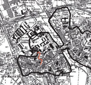
RMP Map showing pipeline route
Monitoring of groundworks for the gas pipe installation took place in November 2010. To minimise traffic disruption the majority of the works were carried out at night under flourescent light. The trench depth was generally between 800mm and 900mm. The stratigraphic profile recorded consisted of tarmac and hardcore infill 0–200mm in depth, below this was a yellow clay mixed with numerous red brick fragments and small stones. This profile was generally uniform throughout but was interrupted frequently by a complex of modern services including water and sewerage mains as well as a number of smaller domestic connections. No finds, features or materials of archaeological significance were recorded.
Declan Moore, Moore Archaeological & Environmental Services Ltd. (MOORE GROUP), Corporate House, Ballybrit Business Park, Ballybrit, Galway.
This entry was posted on Friday, July 8th, 2011 at 10:39 am. It is filed under About Archaeology, Excavations and tagged with 2010, archaeological consultants, Archaeological Monitoring, Athlone, Declan Moore, excavations, Pearse Street.
You can follow any responses to this entry through the RSS 2.0 feed.


