RAHEEN MILL EXCAVATION, CLONMEL, CO. TIPPERARY
Author and Director: Billy Quinn
Here’s a summary of excavation work carried out by Billy for Moore Marine at Raheen Mill, Clonmel, Co. Tipperary last year. The work was carried out in advance of the construction for a flood defence wall on the southern side of the River Suir at the site of the former Raheen Mill, Denis Burke Park. Conditions at the time were as bad as they are currently and excavation was difficult and uncomfortable to say the least. The work was carried out under licence No. 09E504, between December 2009 and February 2010 by Moore Marine on behalf of Mott McDonald Ireland Ltd., Consulting Engineers.

Desktop analysis of historical and cartographic sources relating to the proposed development record that there was a mill located on this site since at least 1821 (Killaly’s and Leahys Map 1821 & 1831 respectively). According to the 2nd Edition OS map dated 1904 the mill was later converted into use as a smithy and continued to function as such in the possession of the Whelan family until the 1950’s. Beyond this date the building fell into ruin, the upper floors and interior were demolished and the gable walls were reduced to the height of the adjacent river bank walls. What survived above ground until recently were portions of the north, east and west walls. These enclosed a landscaped space with a section of the east wall incorporated into an entrance feature leading into Denis Burke Park.
The full scale excavation of the site followed a programme of archaeological testing that recorded deposits and structural remains associated with both the earlier mill building and the later smithy. During the test phase three trenches were machine excavated exposing an intact paved surface below a layer of modern infill. Elsewhere to the south, testing along the footpath exposed a number of modern services that truncated the mills entire southern range.

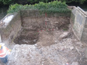
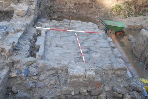
The excavation was carried out over a six week period with a team of four. The excavated area extended 13m E/W by 9.5m N/S from the northern riverside wall to the roadside kerb of the footpath. Internally the mill measured 5.6m E/W by in excess of 10m to the south. Within this area the excavation reduced the ground by approximately 1.8-2m, exposing the underlying natural silt and bedrock.During the removal of the overburden, which contained frequent amounts of heavily corroded iron debris and other modern finds, a mill stone and stone quenching trough were discovered. Both these finds define the buildings use over a period of 200 years. Also re-exposed was the stone pavement found during testing. This floor was cut N/S through the centre by a plastic duct that ran from the road to the south and emptied out into the river via a hole knocked through the northern mill wall. The installation of this service, possibly in the early 1980’s damaged much of interior, including both the wheelhouse wall and wheelpit wall to the north as well as disturbing pre-existing layers.
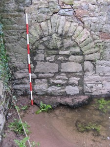
The stone pavement interpreted as the smithy floor, would originally have covered the southern portion of the mill building with the northern half probably used for storage. The floor slabs were set in a rough mortar bed that overlay a charcoal enriched layer. Below this surface was a thick layer of alluvial sand, probably taken from the river bank and used to raise the internal levels of the building when the mill was re-converted to be used as a forge. The mill floor was recorded 0.75m below the smithy floor and was divided into two working platforms; to the south was the millstone floor where the grain was ground and stored, this level dropped down to a rectangular chamber known as the wheel pit. The waterwheel was separated from the wheel pit by a stone wall that survived in very poor condition. The wheel house was evident by blocked up arches in the eastern and western gables. These arches allowed water to flow in from the weir via the head race to power what was probably an undershot vertically set waterwheel before discharging into the river. The waterwheel powered the trundle wheel in the wheel pit which in turn rotated a wallower that turned the grinding stones via a stone nut. Also found in the wheel pit was a sub rectangular stone feature set into a retaining wall that separated both floor levels. This feature had a gradual batter along its elevation and was interpreted as the base of a meal sieve through which the ground grain was bagged.
 To the east of the mill wall excavation took the form of a stepped in trench that exposed the wall foundations at a depth of 2m below the surface level, at which stage the site began to flood. To the west a number of abutting walls were found. These walls do not appear on the 1st or 2nd edition maps and probably date to the early 20th century. As with the structural remains to the south these walls were removed during the installation of the large water main.
Following the excavation of the mill and the recording of the elevations, the mill walls were partially demolished, and were later removed under archaeological supervision to allow the development of the flood defence wall.
This entry was posted on Friday, December 10th, 2010 at 1:58 pm. It is filed under About Archaeology, About Marine and tagged with Archaeological excavation, archaeologists galway, Clonmel Flooding, consultants, galway, mill buildings, mills, raheen mill, Tipperary.
You can follow any responses to this entry through the RSS 2.0 feed.


Hi,
I recently bought a small lead token issued by a Martin Dix. He is known to have issued other lead tokens in Clonmel c.1650. What is interesting about mine is that it appears to have a waterwheel on the reverse. I was wondering if you know of any early waterwheels in Clonmel from around this period? I can email a pic if you are interested.
Best wishes
Baz